


Stevenson étape 7

MMarie
User
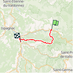

Length
28 km

Max alt
1420 m

Uphill gradient
827 m
Km-Effort
40 km

Min alt
541 m

Downhill gradient
1193 m
Boucle
No
Creation date :
2014-12-10 00:00:00.0
Updated on :
2014-12-10 00:00:00.0
9h23
Difficulty : Difficult

FREE GPS app for hiking
 SityTrail
IGN / Geographical institutes
SityTrail Plus
The world is yours!
About
Trail Walking of 28 km to be discovered at Occitania, Lozère, Pont de Montvert - Sud Mont Lozère. This trail is proposed by MMarie.
Description
Pont de Monvert à Florac
22/07/2012
Michel & Carmen
Positioning
Country:
France
Region :
Occitania
Department/Province :
Lozère
Municipality :
Pont de Montvert - Sud Mont Lozère
Location:
Unknown
Start:(Dec)
Start:(UTM)
559477 ; 4912762 (31T) N.
Comments